
Nov 4 - Nov 5 : Escaping the heat at 9000 ft in the Mainland Mexican Mountains
/After disembarking the ferry in Mazatlán, we were faced with two immediate realities: it was stiflingly hot in the coastal city despite only being 10AM, and we had an entire day to drive ahead of us. Getting off the ferry felt like the end to a long day, but that long “day” had actually been a night, and it was morning, a fact that none of the three of us handled especially well. We were tired, already hot, thirsty, and a little lost. We had kept putting off making plans for what to do when we hit mainland - would we head south along the coast to some beach towns and maybe surf a little, or would we drive up into the mountains, following the Espinazo del Diablo route towards the mining city of Durango, as recommended by Mauricio Parra, adventurer extraordinaire of Ensenada, BCN.
Our first order of business was to find a patch of grass for Gracie, so we navigated to a park marked on Google maps, and while Gracie emptied herself we hid in the shade, gulping down ice cold Electrolit brand sports drinks and forming a plan. We did the sensible thing, trying to learn the lessons that had gone unlearnt so many times before, and checked the weather forecast. The coastal towns to the south of us had similar weather forecasts to Mazatlán, and our little lizard brains wanted none of that, but the towns a couple hours inland showed night time lows in the high 40ºFs so our decision was made and off we went, in search of cooler temps and a good night’s sleep, somewhere on the road to Durango.
Beginning our drive, I knew these things separately: the road was known for its amazing vistas and many switchbacks, our destination was in the mountains, and the forecasted cooler temps were a product of higher elevation. Somehow I had failed to put those truths together and anticipate the enormous climb Walter was about to undertake. The climb started almost immediately and did not let up. We had chosen to drive on the MEX 40D toll road, recently completed in 2013, for all the normal reasons: tolls roads are supposed to be faster, safer, and in better condition in Mexico, as compared to their free or libre counterparts. Immediately, we begin winding up through what looked like karst formations to me, steep walled hills and mountains covered in lush vegetation, with pockets of crops planted by local farmers, I imagine for their own subsistence. Bridges and tunnels seemed to make up half the route, and the drive quickly became a series of dark tunnels that exploded us out into the dizzying heights of a canyon, only to be enveloped by the mountain once again on the other side. The crown jewel of the entire project, and maybe the entire drive was the Baluarte bridge, a cable stay bridge whose deck sits 1,322ft above the valley floor.
We climbed and climbed, with my eyes bouncing from road to traffic to gauges. In moments like these, where we are constantly passing and being passed and dodging potholes while thousands of feet in the air or under hundreds of feet of mountain, driving is a two person job. Chelsea is constantly warning me of oncoming traffic from behind, or passing traffic that is using my lane as well as theirs, as I keep an eye on Walter’s gauges and gears. It’s not an easy job, and I am incredibly glad to have such a talented copilot. Even with her help we’ve found ourselves in some risky situations - I can only imagine without her I wouldn’t have completed a single one of these journeys.
We were only a few hours out of Mazatlán, but everything had changed when we finished our climb at 9000ft above sea level. In just a few hours Walter had transported us from a bustling seaside port to the high-ish alpine villages of Mexiquillo and La Ciudad. The architecture had transformed from the standard concrete block dwellings log and stick-built cabins, a rarity on most of our Mexican travels due to heat and humidity, and we felt like we were in a different world. The fall harvest of wheat was bundled in fields awaiting transport, locals passed bundled up in winter coats and hats and gloves, and smoke from wood fires wafted out brick chimneys. We had left what felt like a costal furnace and ended up in Mexico’s version of a Currier & Ives print.
The change was very welcome. Chelsea and I have made our lives in the mountains of Idaho and Colorado since we met nearly 10 years ago, and we escape to Mexico for the change, to seek the other, to be out of place, but we often miss home and the relative difficulty of the ferry crossing made us cherish this little taste of alpine. We felt normal again, being surrounded by a pine forest, with cold weather on the forecast. Feeling comfortable, we sought out a campsite at local attraction, some sort of eco adventure park. Arriving there we found our German friends and their big overland truck haggling over the price of entry and camping. The park was small and nice and very cool, with really neat cabins and guest house architecture unlike anything else we had seen on the trip thus far. They offered zip lines and tyrollean traverses and other alpine adventure products, but they didn’t seem keen on having overland campers, so we declined a stay and kept on driving. The path we took to get into the adventure park wasn’t very straight forward, and we immediately lost track of our German friends and the big truck, so we headed out a different direction, on what we thought was a more direct shot to the road, but we were mistaken, and the roads turned into trails, and soon Walter was doing a surprise water crossing that was deeper than expected. We figured after the water crossing we were home free, but the trail dwindled from a two-track to a one-and-a-half-track blocked by some downed branches, so we turned around, blasted through the water again, this time with shutter of Chelsea’s camera clicking away, and headed back the way we came.

Chelsea was literally and figuratively melting. We needed a plan and escape route from the heat.

“Zona de Tuneles” on the MEX 40D

Peekaboo views of tunnels and bridges the whole way.

The whole drive was an engineering marvel.

Tunnels and bridges, tunnels and bridges.

We topped out around 9000ft and suddenly we were back in an alpine environment.
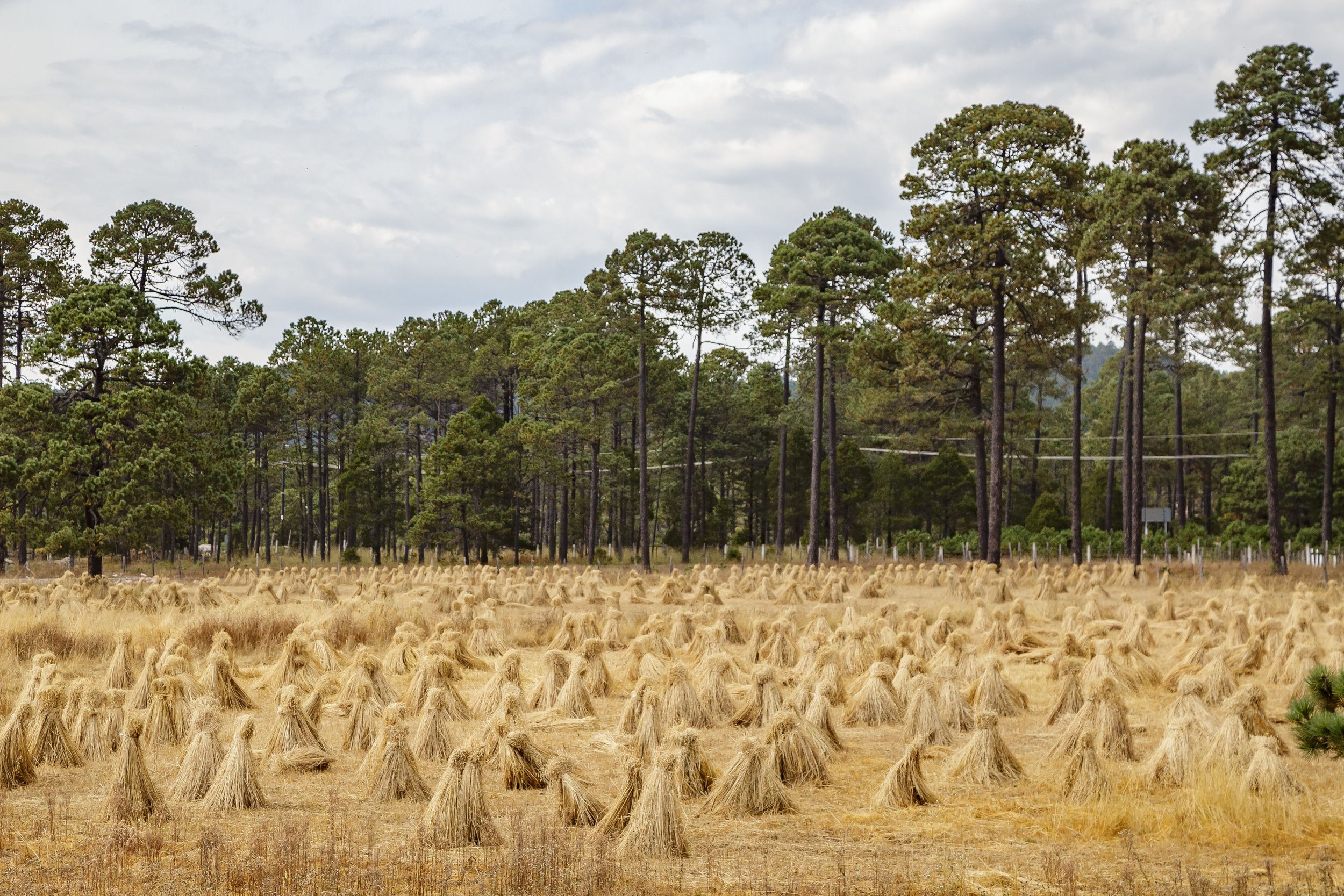
The fall harvest waiting to be trucked away.

Driving around old unused rail grades, looking for a campspot.

An unexpected watercrossing.

Heading back out from the dead end trail that we hoped would take us to the road again - we nearly lost our front license plate to the bow wave!
We ended up at the tourist town of La Ciudad on the outskirts of Mexiquillo, a ”natural park” that celebrates the local ecosystems, the unusual geography, and the modern history of the area. Unusual rock formations and dense forests are surrounded by water features including some wetlands, a small lake, and a really impressive cascade. A few tunnels and manmade ravines dot the area, evidence of a railway project that never came to fruition. The town of La Ciudad was meant to be a temporary camp for the workers, an itinerant community for working on the rail line. It has become something completely different, now a 50/50 split of locals living on the outskirts of town in neighborhoods serviced by crumbling streets, while short term vacation rental properties are established in all the best spots closest to the amenities. Little cabins primped and preened and ready for Instagram photo shoots, a small mountain town relying on the regional tourist economy almost exclusively to stay afloat - no wonder we felt so welcome, its eerily similar to our home in Donnelly, Idaho!
The sun was getting low in the sky, so we hightailed it to the entrance of the park and paid for a night of camping, and in return got a very generic receipt with the word ACAMPAR scribbled across it… so I guess we were good to go? We shifted into low gear and crawled down the park’s roads, made bumpier on purpose for the booming side-by-side rental business. tracks and trails led everywhere, and to the best of our understanding, the “natural park” was essentially an unofficial Off-Highway-Vehicle attraction. The park was protected by the state government, so no more permanent building would take place and entrance was metered, but not protected enough to limit motorized traffic, so the locals had setup tour companies outside the gate, acting as unofficial concessionaires, to take advantage of this OHV playground.
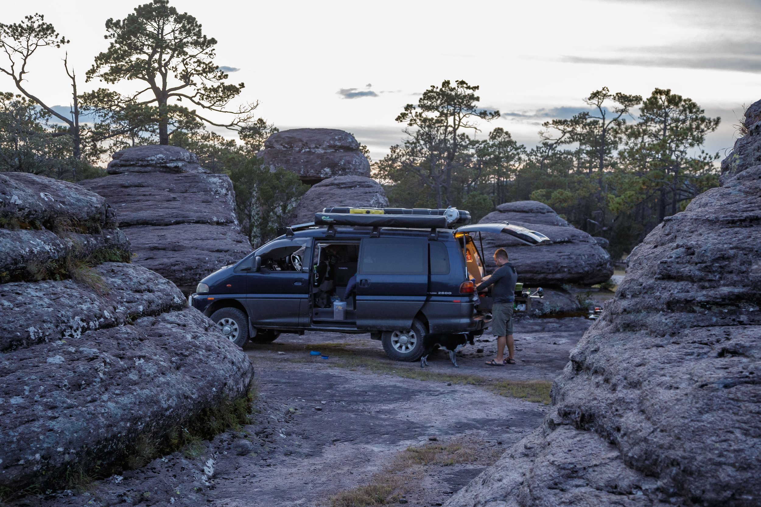
Eventually what looked like a well worn road split into a million tracks, with evidence of travel spreading everywhere. We poked around, trying to follow the most well worn of tracks so as not to stumble into another secret bog hole. We did some really fun dead reckoning, as our map was little better than a cartoon drawing of the area, designed to market the numerous viewpoints of the area but not act as an actual navigation aid. Eventually we found a pull off near some trees and out of direct line of sight of the main thoroughfare, and decided to set up camp. We all fell out of Walter, happy to be done moving for the first time in nearly a day and a half, only to be met by a chorus of dirt bike and quad-cycle engines minutes later. A small pack of tourists, led by two guides, were slowly making their way towards us. Chelsea and I exchanged glances, both of us really not wanting to engage in the standard conversation about our travels, our van, our dog, or our lives that we normally have with interested locals. The motorized group meandered around, maybe 50 meters away, glancing our way and approaching slowly, until they parked so close to us that I got nervous. My hackles were up, and while I didn’t perceive a threat from the group, their proximity to us seemed uncanny. There was a whole park to recreate in, everywhere around us was deserted, why get so close to us? They switched off their bikes and quads, dismounted, and suddenly we were out numbered eight to two, but they just filtered past us, talking amongst themselves by a rock formation, paying us no mind. None of this behavior would have warranted a second thought anywhere else, except that it was nearing sunset in an otherwise empty part of the park, and it seemed like we had been sought out.
A few of the group were drinking beers, and some of them started climbing rock formations next to our van. I approached what looked like their guide and clumsily asked if this spot was a popular viewpoint, to which the answer was yes. It seems we had decided to set up camp in the heart of one of the more photogenic attractions, not much different than pitching a tent at the foot of the Haunted Mansion, so I gestured to my left and asked Muy tranquilo? to which I received an understanding Sí, sí.
Feeling much less threatened, we hastily fired up the van for the last half a kilometer of our journey, and found an even more private spot just around the corner. Finally breathing a sigh of relief, and finally making good on our promise to the dog that we were done for the day, we set up camp. The golden light of the evening was descending on the rock forest, so Chelsea put her drone in the air for some photos of the area and a few family portraits before a cool, quiet, and uneventful nights sleep, thousands of feet above sea level.

Our first camp spot. Little did we know it was a popular viewpoint for tours.

Posing with the dog at camp spot one. Moments later, I would watch a whole tour take photos here, but it was my idea first!

The forest of rocks at Mexiquillo.

The dirt bikes and quad cycles that spooked us.

“well, this place is toooooo crowded, time to move on.”

Camp spot number two, and family portrait number one.

Family portraits in the forest of rocks, Mexiquillo, Durango, Mexico.

Sunset over our camp spot.

It was a great area for some disc throws, but we had to be careful of broken glass, it was EVERYWERE.

Tired dog, tired travellers.
Camp cooking in the forest of rocks. I think we had quesadillas .
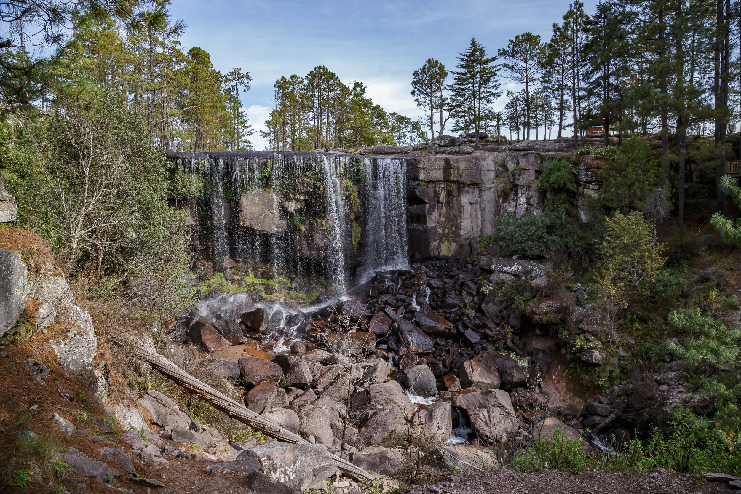
Going to sleep with the sunset meant we were in bed before eight and up early too. We had the park pretty much to ourselves the next morning, and we couldn’t say no to a quick tour around the area before making our way out to the road for bathrooms and breakfast. Our cartoonish map showed a cascada nearby, one of a handful of attractions, and the one most fitting us, so we took off in that direction, navigating mostly blindly through the forest of rocks. A parking area opened up near where we thought the cascade might be located, and there were a couple of locals setting up a trailered porta-potty (ten pesos per use) who confirmed that we were in the right spot. We paid them to watch the van and we headed off on an exploratory hike, following the siren sounds of whitewater.
Not too far from our parking spot we found the outflow of the small lakes and wetlands in the park, and the bedrock layer we had been driving on gave way to a cliff, sending the water falling down a set of cascades, before it exited through a tunnel and into the river canyon below. A trail led down into a manmade ravine, I suspect it was to be part of the rail grade before that project was abandoned, and we followed well worn, hand made wooden staircases to the base of the falls, and then a small social path to the waters edge. Early morning sunlight was still just spilling through the trees, making for great photos, and the three of us were alone in an amazing place that we had just happened upon. We had driven long and far, but not without reason, and not without reward.

Driving over bedrock ledges, looking for waterfalls.

There were obvious signs of motorized use, but the trails were really wide in some places, making navigation a little tricky.

Searching for waterfalls by listening for whitewater.

The cascade at Mexiquillo.

The view from the rail grade looking down stream and down valley - this photo is taken from above tunnel in some of the following photos.

One of numerous hand hewn, hand made wood viewing platforms at the cascades.

An absolute treat of a mini-hike that morning to the cascade.

Chelsea and gracie walking down the rail grade.

Portraits on the rail grade.
Another view of the casacde.

Tired dog enjoying the cool rock.

Taking photos of a tired dog.

The tunnel outflow at the Cascade at Mexiquillo.

Family portrait at the waterfall!

Family selfie above the waterfall.

One of the tour vehicles shuttling sightseers into the attractions at Mexiquillo.

A convoy of 4x4 tours entering the waterfall area as we were leaving.